
BRUNANBURH DISCOVERED
By W.H.Lawrenson
In the year 937 one of the bloodiest battles ever to take place Great's grandson, Athelstane, was invaded from Ireland by an army of on British soil was fought when the Saxon kingdom of Alfred the Danish Norsemen and native Irish led by Olaf Gruthfrison the Norse king of Dublin, in alliance with Constantine, king of the Scots and
the Welsh Princes Idwaland and Owain.
Gruthfrison made a surprise landing on British soil with a fleet of 615 ships with the intention of linking up with the Scots and Welsh armies to give an estimated force of some 30,000 men. However, to be found amongst stories of the heroic deeds of warriors and heroes related by the old Icelandic Saga men, is the story of a great encounter which occurred near a place known to them as Brunanburh and its subsequent battles.
Even at the time, the country around Brunanburh would not seem to have been very well known for they go on to paint a very detailed picture of the landscape over which these battles were fought. Even with this, the exact location was forgotten and has never been satisfactorily established, which would perhaps suggest that the events took place in some isolated and sparsely populated part of the country. In fact, a place that the world forgot. Nevertheless, over the years anywhere in the British Isles with 'Brun' as a prefix has been put forward as the possible Brunanburh without any convincing evidence.
One often-quoted theory is that Olaf Gruthfrison's fleet landed somewhere on the Humber estuary, but there would not seem to be any logic in this argument. Firstly, it would be difficult to maintain contact during the long and dangerous sea crossing, and the time spent at sea would seem to rule out the element of surprise. Secondly, on their march to the east coast to link up with the invasion, the Scots and Welsh forces would be vulnerable to interception by the Saxon armies, which would make the timing of their meeting with Gruthfrison almost impossible, and again the element of surprise would surely be lost.
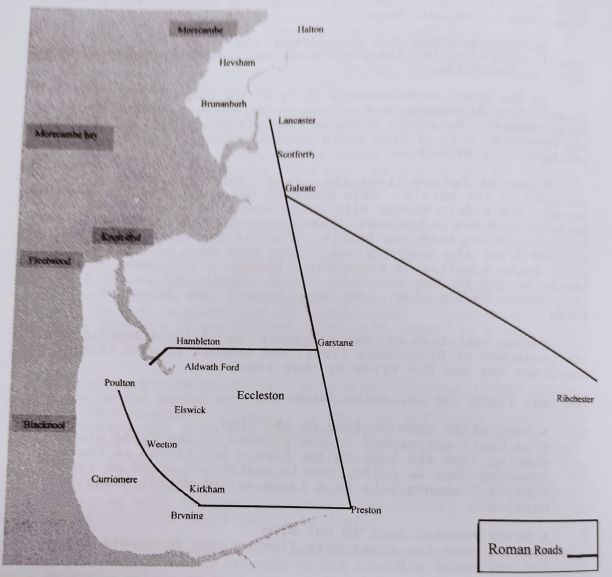
But, what does seem to have been overlooked by most historians is the fact that the name Brunanburh did actually exist in the shape of a detached pillar of sandstone rock which stood between Middle- ton and Heysham near 'The Red Nab' but which was removed when Heysham harbour was built. This red pillar of rock standing out from the sandstone cliffs would have been well known to generations of invading Norsemen and used by them as a guide to the Lune estuary. While at the southern end of Morecambe Bay, near the ferry slipway at Knottend, stood two stone cairns, 'The Great' and 'Little Knotts', which according to local tradition were built by the Norsemen to guide their ships into the River Wyre. These were also removed in the 19th century being a danger to shipping when the port of Fleetwood was developed.
So, here we have in Morecambe Bay a short sea crossing with a ideal for a massed landing and standing on an ancient north south landfall well known to the Norsemen, a wide expanse of level beach
ideal for a massed landing and standing on a ancient north south route providing an easy access to the Scots and Welsh invading
armies. In the vicinity we have the old interconnecting Roman road system, which must have been well used by the raiding Norsemen in the past and which would lead them through the Pennines and so on to Athelstane's capital, York.
Further evidence for our theory can be gleaned from other reports of the battle. The place names mentioned have parallels to be found in the Fylde.
In The Saxon Aethelweard's story of the battle, he refers to a place called Brunadune, and we have on the western bank of the river Wyre, opposite Barnaby's Sands at Preesall on a slight hill or dune, the Domesday Burg of Brun which could conceivably give us Brun on the Dune- or Brunadune.
Simon of Durham gives the name Weondune as being in the vicinity of the battle. This could be the Wideton of the Domesday Survey, the modern Weeton Hill which would be a well-known land- mark and look out in the area. Even the word Fylde itself could have some connection with the battle. The old English word 'Fylde' is derived from the word 'fyllan' - 'to cast down or destroy'. This would imply a battle or slaughter. Perhaps a reference to a great battle fought in the district. It is significant in this regard that south of Heysham, the Lune estuary was known as 'Little Fylde'.
Now we must turn to the Icelandic Sagas for a description of the landscape of Brunanburh itself and compare it with that of the Morecambe Bay and the Fylde at that time.
The Saga lists the following landmarks:-
1. A VAST HEATH RUNNING AWAY ON ONE SIDE
This could correspond to the expanse of the Fylde plain running from the Lune to the Ribble and listed in the Domesday book as being 'mostly waste' and would at the time of Brunanburh be to a large extent mainly heath and mossland
2. A RIVER RUNNING AWAY TO ONE SIDE
Here we have the river Wyre flowing into Morecambe Bay on the northwest side.
3. A FORD OR PASS OVER THIS RIVER
On the Wyre at Hambleton is the ancient ford of 'Aldwath', it being a Norse word meaning The Old Ford.
4. PROXIMITY TO THE SEA
At Morecambe Bay
5. A GREAT WOOD ON ANOTHER SIDE.
The eastern side of the Fylde Plain would still be well wooded. With the great forest of Curridmere in the south- west corner now the moss lands to the west of Ballam.
6. A BURG TO THE NORTH AND ONE TO THE SOUTH WITH A DAYS JOURNEY BETWEEN THEM
At the northern end of Morecambe Bay we would have the Burgh of Halton and to the south that of Kirkham with the distance between approximately a full days journey.
The sighting of the invasion by Earl Alfgeir, governor of the northwestern province coupled to the news of an approaching Scots army and the certainty of having to face a massive force, obliged Alfgeir to flee to Athelstane with the news without offering any resistance.
On receiving this news, Athelstane dispatched an army uder the command of the Earls Thurcytel and Syngrin to intercept the Scots army before they could rendezvous with Gruthfrison on the coast. They were able to ambush the Scots at a place known as 'The Scots Ford (Scotforth? approximately 1 mile south of Lancaster) and achieved a total victory. In the meantime Earl Alfgeir reinforced by a company of Viking warriors led by their war chiefs, the brothers Thorolf and Egil, was returned to guard a ford over the river to prevent a breakout of the invaders from the coast.
Situated at Hambleton on the route of the Roman road from the The church, school and church hall occupy the whole area at the Wyre to Garstang is a large moated site that has now been filled in. present time. There is mention of a Manor House being here in 1200 of masonry below the surface of the churchyard. Its siting would A.D. Gravediggers have come across a paved road and various pieces make it the ideal place to build a fortification to guard the river crossing at Aldwath Ford.
This would be the spot where Alfgeir and his Viking allies would about recruiting a large army to march to the coast and engage the take up their defensive positions. In the meantime, Athelstane set invaders. Gruthfrison decided to force the ford using his Irish and Welsh warriors in a surprise night attack. Earl Alfgeir turned coward and fled but the Vikings under their chiefs Thorolf and Egil held fast. One of the Welsh princes, Owain, was killed and the defending Saxons, amongst them Wulfstan, Bishop of Sherbourne.
Gruthfrison then attacked with the Danish Norsemen to be confronted by Athelstane who had arrived on the scene.
After many hours of bitter fighting, Athelstane was reinforced by the arrival of Earls Thurcytel and Syngrin fresh from their victory over the Scots. With this new onslaught, Gruthfrison's line broke and fled to the coast and their ships, many of them being cut down by the victorious Saxons and Vikings as they tried to launch
them.
In former times in the little village of Bryning near Wrea Green, the locals would always refer to the village inn as 'The Bloody Pluck' which, according to the story, was near the spot where, after a great battle, the intestines of a captured Prince were hung on a thorn bush as a trophy and warning to others. Could this be the folk memory of some Welshman who, after Brunanburh, was captured whilst fleeing back to his own country?
In the carnage, five kings including the son of Constantine, King of the Scots and seven earls were killed. On the Saxon side losses were also very heavy. These included two sons of Aethelweard, Alfred the Great's youngest son, the Viking chief Thorolf and Bishop
Wulfstan.
This great carnage is related in the Sagas epic poem:
'The northmen retired bloody remnant from the spears in their nailed barks on roaring ocean Dublin to seek o'er the deep water
and Ireland once more with minds in shame.
Carnage greater has not been in this island never yet of people slain before this since from eastward hither Anglo Saxons came to land.
The Viking Egil returned to the battlefield and retrieved the body of his slain brother Thorolf and buried him according to Viking Custom with all his weapons and a gold ring clasped on each arm. They piled stones over the grave and covered them with earth.
This burial mound still awaits discovery. Mounds as far apart as Dane's Hill at Elswick and Torrisholme have been suggested, but local tradition has maintained that a Viking warrior chief was buried near the Saxon church at Heysham and some credence was given to this belief when an elaborate Norse Hog-backed tombstone was discovered in the churchyard. Could this be the last resting place of Thorolf carried there by his brother to lie in a very ancient Christian place.
This may not be as far-fetched as it would at first seem when one considers that when the Viking brothers joined Athelstane's band they were both baptized, and became Christians. So it would not be unreasonable to suppose that Egil with all the zeal of a convert should want his brother to rest in that sacred Christian site.
Athelstane rewarded Egil for the part he and his brother had played in the great victory by giving him presents of money and land. This land could only be around Great Eccleston and Elswick, which are named in the Domesday survey as Eglestun and Edelswie the manor and village of Elgi.
He remained in England for around twelve months, perhaps to parcel out his land to his followers who wished to settle and remain in England, he himself returned to Norway to marry his brother's widow.
Now we come to the last part of the jigsaw to complete our theory as to the site of Brunanburh.
In the same year as Brunanburh, Athelstane made this grant to the Church of York:-
I Athelstan king of the English and ruler of all Britain do freely give to the Omnipotent God and to the Blessed Apostal Peter, at his church in the diacese of York, a certain section of land, not small in extent, in the place which the inhabitants call Amounderness, a land which I have purchased at no small cost'.
The wording of this grant would seem to be something of a puzzle, for why would the King, who owned the land anyway, have to purchase it 'at no small cost'. Probably Athelsltane was not referring to a cost of money, but to a great cost in the lives given in assuring that Amounderness remained in Saxon hands. So it would seem only natural that he would wish to give to the Church the very land on which this great victory had been won.
Now we have examined the evidence and all the facts have been put in place, it would not be unreasonable to suppose that the events of Brunanburh did indeed take place around Morecambe Bay and the
Fylde.
SOURCES:-
'Morecambe and Heysham' R.C.Quick
'Bygone Days in Hambleton in The Fylde' by J.Daresbury Hatton 'History of Blackpool and its Neighbourhood' by Rev. W. Thornber 'The Over-Wyre Historical Journal Vol. VII'
'Battle Fields of Britain' by David Smurthwaite
'Transactions of the Lancs. and Cheshire Antiquarian
Society, 1943-1946'
'New Light on the Battle of Brunanburh' by C.P.Hampson F.S.A.
'Further Views on Brunanburh' by Dr.F.W.Hogarth
'Place Names of the Fylde' by C.P.Hampson, F.S.A.