
The Origins of Calder Vale and Oakenclough
by Julia M Beeden
Calder Vale and Oakenclough are two small settlements on the River Calder, sometimes in the nineteenth century referred to as the West Calder in order to distinguish this minor river from those of the same name in Yorkshire, Lancashire and modern Cumbria. Calder Vale has developed into a small village but Oakenclough is still a small community and a dispersed settlement with no true focal point. The two settlements are about half a mile apart and some three miles East of Garstang on the River Wyre, of which the River Calder is a tributary. Situated at SD54 533458 and SD54 537476, they are isolated from the main Lancashire Plain by hills, principally Sullom Hill in Barnacre and sheltered from the North and the East by the hills of the Bleasdale Forest. Apart from isolated farms, the ravine-like valley of the Calder was a virgin site. No map, pre-1835, shows the community nor is there placename evidence earlier than the nineteenth century.
Calder Vale was created in 1835 (1) by Richard and Jonathan Jackson who, with their brother John, had originated at Spout House in Nether Wyresdale (Scorton) as yeoman farmers. The Jackson family belonged to the Society of Friends and could trace their ancestry back to one William Jackson of the Quaker Meeting, House at Brighouse in the West Riding of Yorkshire, in the mid-seventeenth century (2). Richard Jackson (died 1846) lived at Calder House in Bonds township, just below the present Garstang High School. He gave land behind his property on which was built, in 1828-9, the Quaker Meeting House with burial ground and temporary stabling. This became known, after 1846, as the Calder Bridge Preparative Meeting, a part of the Lancaster Monthly Meeting (3). Jonathan Jackson lived on a farm above Calder Vale in Barnacre, then known as Shaws, owned in 1839 by his brothers and himself (4). Near to this farm he built Vale House, the predecessor of the present building of that name.
Oakenclough was already a named settlement in 1827 when John Jackson bought the paper mill, land and a farm, from Richard Curtis, a paper manufacturer and farmer of Heald Farm in Barnacre, who had gone bankrupt (5). John Jackson built and lived at the adjacent owner/ manager's house known as Calder Bank, which is now a restaurant. His descendants continued to live there for well over one hundred years. The most famous member of this branch of the family was John's grandson, Harold Jackson (1866-1947), a well-known public figure and inventor.
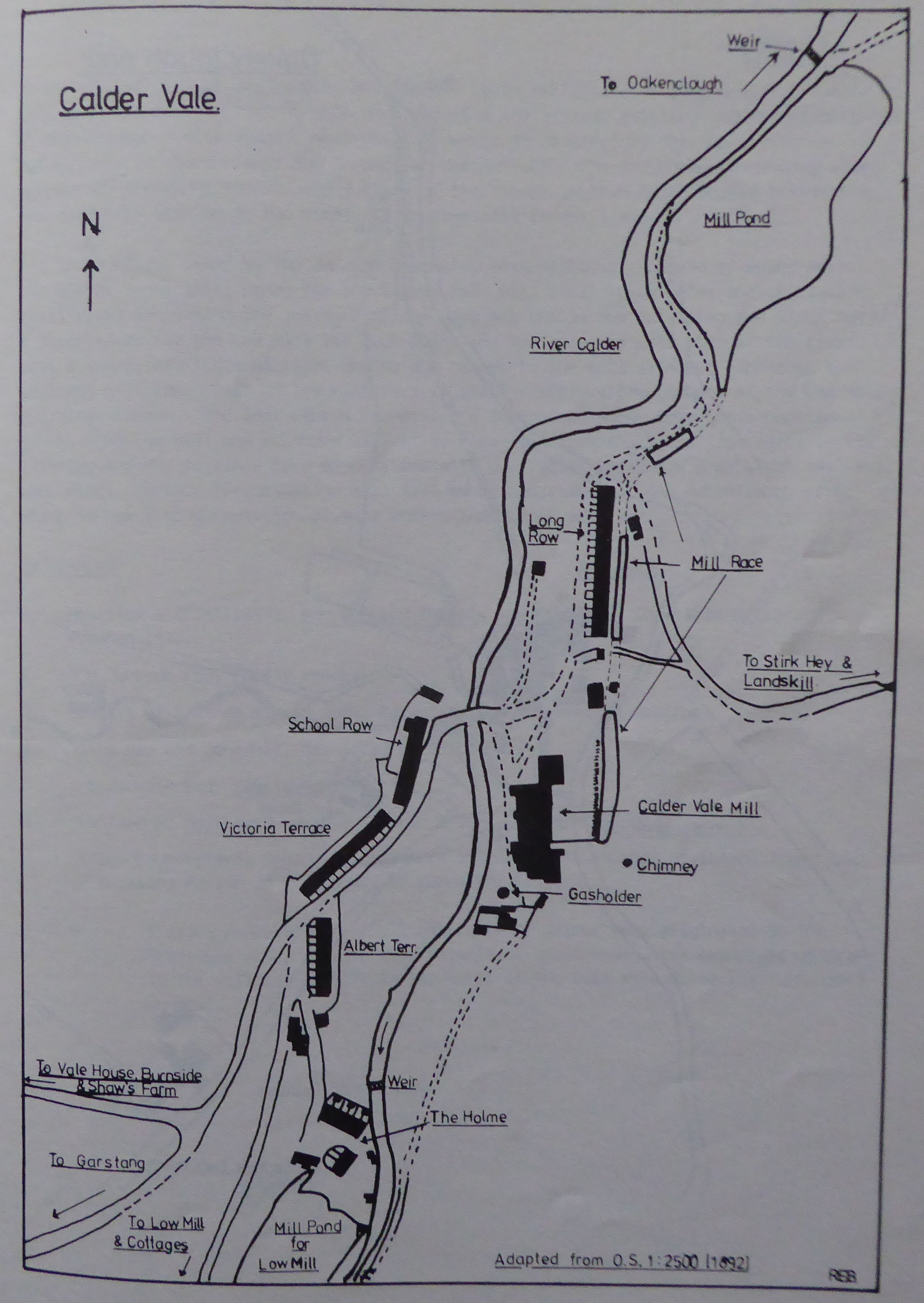
The model village of Calder Vale was commenced, in 1835, by the building of Calder Vale Mill for the purpose of cotton spinning. It is now known as Lappet Mill and is owned and operated by Courtaulds Limited. Housing had to be provided for the workforce because of the isolated position of the mill site in relation to local centres of population.. The houses were built on the valley land that was already owned by the Jacksons.
The Low Mill at Calder Vale was probably built around 1848 (6) for cotton weaving, presumably by Jonathan Jackson. It is understood that the cotton waste from the mills was carted up the valley to the mill at Oakenclough and used in the paper-making process there.
So a model village at Calder Vale was created by an enlightened entrepreneurial family with the intention of fitting into and improving the already existing industrial potential at Oakenclough. Accordingly, more housing needed to be provided for the workforce, at Calder Vale in its entirety and in part at Oakenclough. The two communities were always connected, though different, and a study of the Census records found people resident in one community working in the other, as in even more recent times.
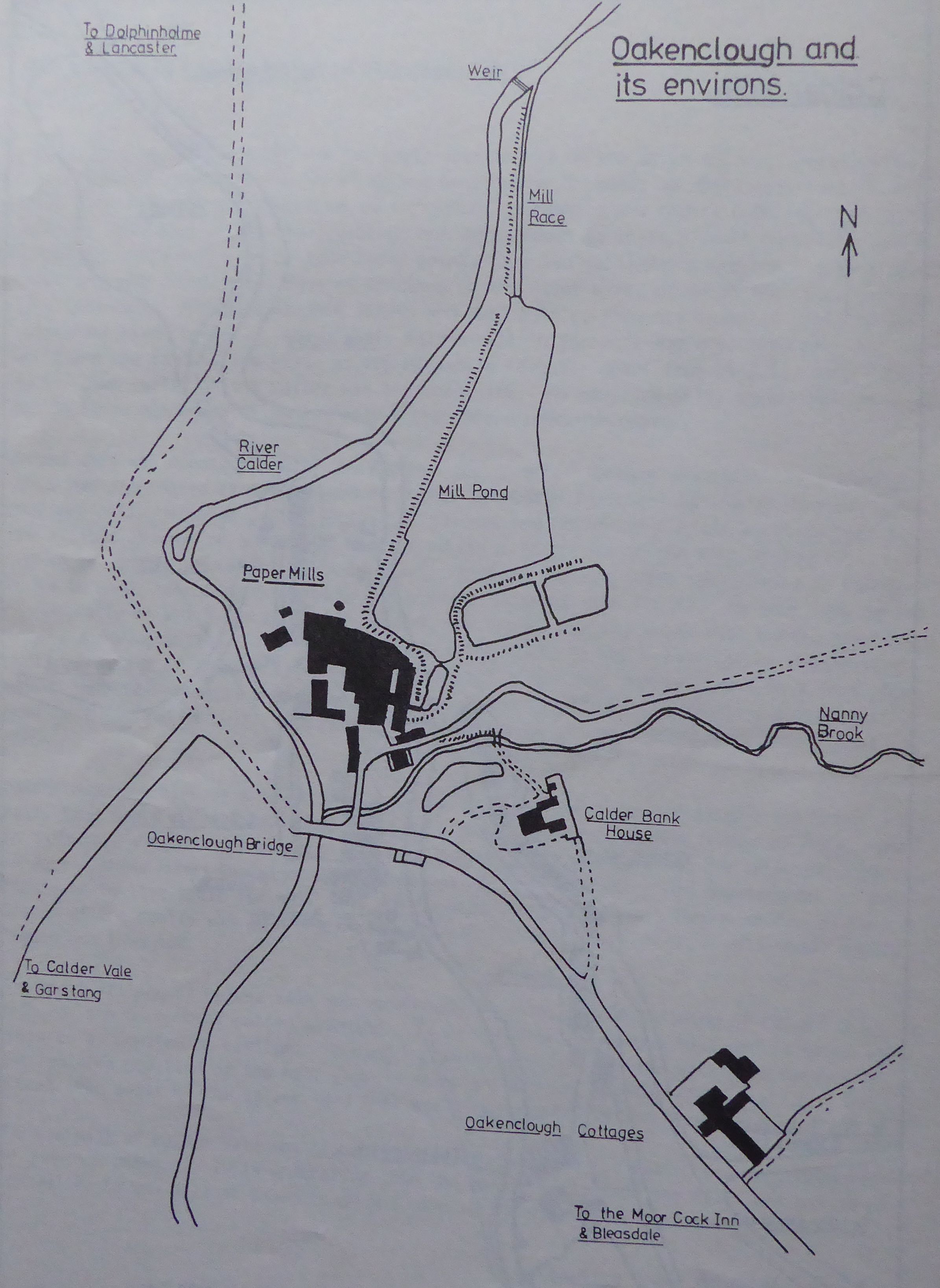
All three mills, owned by the Jackson brothers, were originally worked by water power. The dam or lodge (mill pond) for the Calder Vale Mill still holds water and its leat (mill race) ran behind the cottages called Long Row but is now culverted and piped away. A large lodge for the Low Mill lay just below The Holme on the west side of the river, with a subsidiary lodge at right angles and nearer to the mill site but higher up the adjacent hillside. Part of the mill race is still visible although none of the Low Mill buildings remain. The 1851 Census Enumerator's Schedules (7) show, from the occupations given, that Low Mill was equipped with steam power to drive the looms from early in its lifetime and may possibly have been fitted with dual water and steam power from the very beginning. Further investigation will have to be undertaken of the Oakenclough site, which is now a conglomeration of more modern industrial activity.
References
- Hewitson A ("Atticus"), Our Country Chapels and Churches, Chronicle Office, Preston 1872.
- JD Jackson Esq, Family Papers.
- Society of Friends Minute Book, Calder Bridge Preparative Meeting.
- Tithe Map and Schedule, Barnacre Township, 1839.
- JD Jackson Esq, Family Papers.
- Hewitson A, Northward, George Toulmin & Sons, Preston, 1900.
- Census Enumerator's Schedules, Barnacre and Catterall (Higher Division) Townships of Garstang Parish in the County of Lancaster 1851.
Footnote:-
A large proportion of the inhabitants of Calder Vale originated in the Over-Wyre area. For further details of their names, the reader is referred to the writer's article in Volume II of The Over-Wyre Historical Journal.