
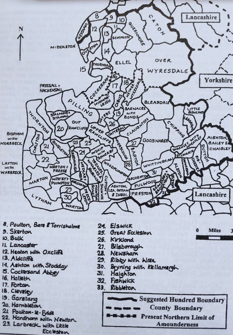
The Shire of Amounderness
By Richard Watson
The ebb and flow of territorial power in north west England during the period after Roman power became ineffectual in these islands, brought about confusion regarding the boundaries, status and indeed the names of territories. However, certain areas seem to have retained an identity despite the turmoil produced by the rise and fall of ruling dynasties and a few of these have survived until modern times. The following account is an attempt to investigate one such area the original territorial extent of what was later termed the hundred of Amounderness. It has been far too convenient in the past to dismiss the earlier history of this district with the stock phrase "Oh yes, part of Yorkshire, wasn't it?", but there is a lot more to its development than that, and the Yorkshire connection (1) seems simply to have been a relatively late bureaucratic convenience.
Although there is an earlier reference to the region, dealt with below, the first surviving record of Amounderness by name occurs in the grant of 934, whereby king Athelstan gave Agmundes ness to the church of St. Peter in York (2) A recent review of the boundaries of Yorkshire (3) gives the northern limits of this grant as follows: the river Cocker, from the sea to its source, then over the short distance east to the Damasgill stream above Shireshead (4) in Wyresdale; south until that stream joins the river Wyre; thence to one of the Wyre headstreams at Marshaw; then across the fell to the rivers Brennand, Dunsop and Hodder and so to the Ribble.
Since the 10th century survey of the boundaries was made there have been some minor adjustments to the 'official' area of Amounderness. Some of the eastern portion of the land granted at that time Aighton, Bailey and Chaigley was added to Blackburn hundred. The other 'encroachment' occurred at the junction with Cockerham township, which should logically have ended at the river Cocker, but for some reason was subsequently extended across the mossland to the Wram Pool. (5) The present writer thinks that this may be because in the early medieval period Cockersand abbey was granted the manor of Pilling. Cockersand itself was then defined as an extra-parochial portion of that manor, the occupants of which thereby gained certain rights over the Cockersand land in Cockerham. The encroachment into the land formerly part of Pilling may have been in compensation for the acquisition of those rights.
The region in question can only have acquired the Norse appellation of 'Agmund's ness' during the 10th century, when the Norse-Gaelic peoples from the Western Isles, Ireland and Mann colonised it. (6) F.T.Wainwright suggests (7) that the main period of such activity was between 900 and 930, and there is the possibility of the Agmund in question being alive and active between these dates. Only a very short time therefore separates this colonising phase from the year 934, when king Athelstan acquired Amounderness from whoever was the ruler of that territory (perhaps the heir of Agmund).
However, whatever the precise steps in the formation of Amounderness as a territorial unit, it is certain that the region had been a desirable property for well over a century before this time. Eddius Stephanus, writing of the building of the church at Ripon (c 671-678), records that St. Wilfrid the bishop accepted the lands which the kings had given him for its maintenance and named them. (8) The part of the land given to Wilfrid which is relevant to this paper was then described as 'iuxta Rippel et Inga Edyne' and there is an implication that these names referred to points at the extremities of the area in question. John Leland notes in his itinerary of the 1530s that 'iuxta Rippel' is Amounderness (9). But what of Inga Edyne? It has been suggested that it is the modern Yeadon, (10) but if the area is limited to lands next to the Ribble and in Northumbria, which seems a reasonable assumption, this conclusion is implausible. As the name stands, it could mean 'the place of the followers of Eden', but we might also consider the possibility that Eddius had created the name Inga Edyne to substitute for something such as Ysgor Eidyn, a possible British name meaning 'the fort of Eden'. This theory would mean that we must look for the location of an 'Eden' somewhere north of the Ribble, which at this time was being recognised as the southern boundary of Northumbria. It would be tempting to go straight to the Eden valley in Cumbria, but for that to have been the northern boundary of Wilfrid's lands would imply an overall area of surely excessive size.
Nearer home, however, there is a clue north of the Ribble but within Lancashire indeed, within the bounds of Lancaster itself. This is the minor name Edenbreck, on the northern slope of what is known locally as Cannon Hill, near the new estate of Abraham Heights on the southern edge of Lancaster city. The name occurs as early as 1285 (11) and, as Eden does not seem to be a Norse personal name it can perhaps be interpreted as meaning 'the slope (brekka) of a place named Eden/Edyne'. The site slopes down to the southern bank of the Lune and is in a very strategic position. Perhaps the survival of such a small and obscure placename indicates that it previously had a greater significance.
I would therefore suggest the possibility that Edenbreck was would have been in the vicinity of the river Lune, a theory which is Located near the northern boundary of the pre-Norse 'hundred' which supported by the fact that the medieval deanery of Amounderness included the ancient parish of Lancaster; deanery boundaries are widely acknowledged to have been of great antiquity even in the 13th century. In 934, when it was granted to Wilfrid and Ripon, this larger territory had recently come within the jurisdiction of Anglian Northumbria, but what had it been before that time? One possibility is that it was a unit within the early post-Roman kingdom of Rheged which occupied modern Cumbria and beyond. It is almost certain that there were a number of petty kingdoms in the north after the departure of the Romans and some of these retained their identity in a different form - as hundreds or wapentakes - for centuries after they had formally been absorbed within larger units. A typical hundred would have had two early administrative centres and Amounderness has one such place which might be identifiable - at Treales, in the middle of the Fylde, the name is thought to be a combination of the British words tref (township or district) and ilys (court). Ekwall (12) notes also the adjacent township names of Wharles ('mounds standing within circles') and Roseacre ('land with cairns'), and this association of exceptionally unusual and significant names clearly has considerable historical implications. Perhaps Ysgor Eidyn was the other centre?
The larger area here postulated, extending from the Ribble northwards to Lancaster parish, may thus have been a sub-kingdom or minor territorial unit in the post-Roman period, later defined additionally by being owned by Agmund, and eventually granted as an entity to Ripon. It must have had a particular name, known to its people and to those of surrounding territories and derived either from topographical or tribal origins. Later, the southern two- thirds, more closely defined, acquired the name of its Norse landowner, Agmund, but could the name of the original unit have been Eden, a term surviving in the Edenbreck of Lancaster?
1. In the Domesday Book of 1066 Lancashire north of the Ribble, together with south Westmorland, Furness the Millom area, is included in 'the king's lands in Yorkshire'.
2. W.Farrer (ed.) Early Yorkshire Charteres (Edinburgh, 1914)
3. H.J.E. le Patourel, M.H. Long and M.F. Pickles (eds.), Yorkshire Boundaries (Yorkshire Archaeological Society; 1933), chapter 9.
4. This may have been when Shireshead received its name, as it was situated in a projecting area of land within the boundary of the 934 grant.
5. The name of a minor watercourse in Pilling.
6. G.Fellows Jensen, Scandinavian settlement names in the North West (C.A.Reitzels-Forlag, Copenhagen, 1985)
7. F.T.Wainwright (ed. H.P.R.Finberg), Scandinavian England (Phillimore, 1975) p, 222
8. B.Colgrave (trans. and ed.) Eddius Stephanus 'Life of Bishop Wilfrid' (C.U.P., 1927), pp. 35-37.
9. John Leland's Itinerary (Surtees Society, Vol.74)
10. Colgrave, Eddius Stephanus, p.164
11. E.Ekwall, The Place Names of Lancashire (M.U.P.1922 p.10)
12. E.Ekwall - Place Names p.152.
This paper was published originally in Lancashire Local Historian, No.12 (1977).