
Ancient Earthworks At Nateby
By J. Salisbury
Nateby Parish extends from half a mile to three and a half miles due west of Garstang and contains 2,080 statute acres. The district is agricultural and of stock farming nature. The adjoining parish is Kirkland, which contains an area of 974 acres. A farming 'complex' thought to date back to prehistoric times has recently been discovered here at Nateby situated on high ground near to the centre of the present day village. It is probably best described as a broad, circular band of high ground, roughly of a doughnut shape, with the centre being low lying and containing a small lake. The area of the complex covers about 300 acres in all.
We now know that due to climatic changes in the period 1,000 to 800 B. C. the lower areas around Nateby would have become swamps with peat starting to form. We also know from artefacts found beneath the peat that settlements existed here in these low areas, and doubtless it would have become more and more difficult for the inhabitants to survive. The presumption is that they came to settle on the nearby high ground.
The most striking of the earthworks to be found are the very great number of field enclosure ditches. These form the so-called Celtic fields, which are small, squarish plots of a half to two acres in size. Groups of these, representing small farms or settlements can be seen. there are also later field systems superimposed on the earlier ones. These have much deeper ditches enclosing larger areas, making ploughing in the area impractical. These enclosures, with their narrow bottoms and gradually splaying sides, are very much different in construction to the drainage ditches found in the lower areas.
A general survey of the area was carried out by members of the Pilling Historical Society. (Permission was first obtained from various landowners in Nateby village and we are indebted to them for this.) The aim of the survey was to explore the archaeological and historical character of the area. Whilst not claiming to be comprehensive, the survey showed a whole range of surviving evidence, probably covering nearly 3,000 years of continuous human settlement. A number of potential sites discovered in the course of the survey have still to be investigated.
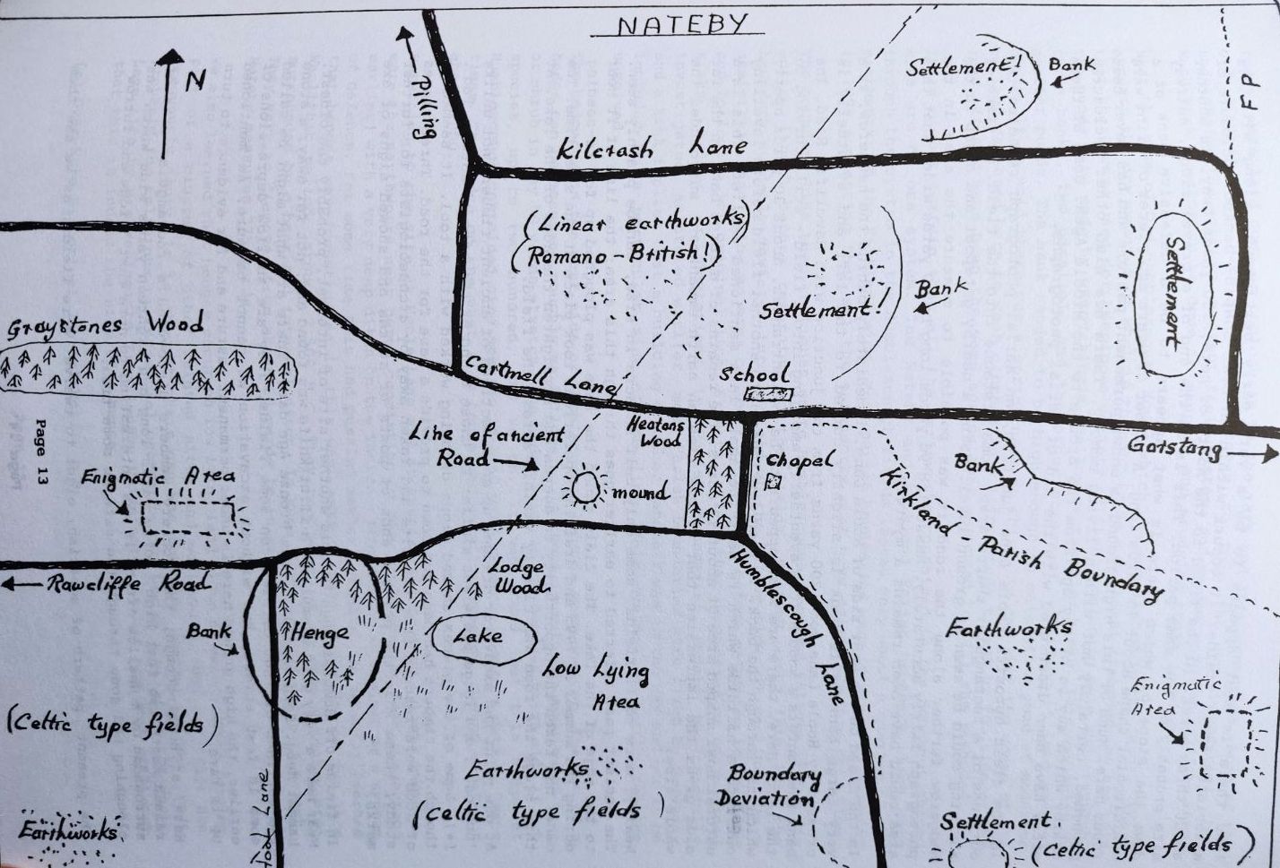
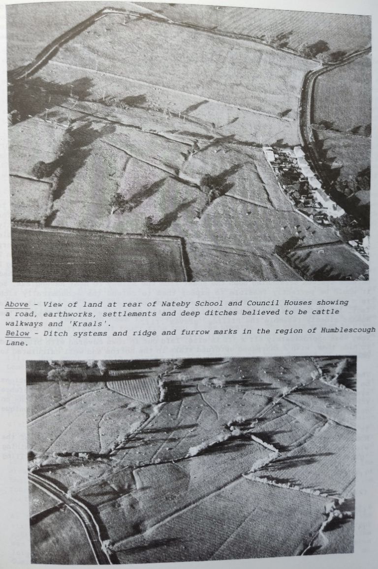
In the field to the rear of the village school there are also a number of enigmatic earthworks, having the usual enclosures but with a difference. Some of them have been deepened and widened in order to create a system of what are thought to be cattle walkways. These lead into what appears to be dug-out pens in the centre of the runs. Society members took some measurements of the largest. One measured 216 feet long, 18 feet wide and 10 feet deep and another 126 feet long, 24 feet wide and 7 feet deep. Others appeared slightly smaller. Even allowing for collapse and decay, the sizes are still impressive. It is widely thought that their purpose was primarily to form a shelter into which stock could be collected when the need arose, and where those animals which could not be kept through the winter were slaughtered. There is a similar system to be found on Levisham Moor and another in the parish of Hutton Buscell in North Yorkshire.
Also discovered in this field was a section of very ancient road - possibly Roman. It is 18 feet wide, cambered and with a paved surface of cobblestones (some of which had been broken) and a shallow ditch on each side. It follows a southwest to northeast direction.
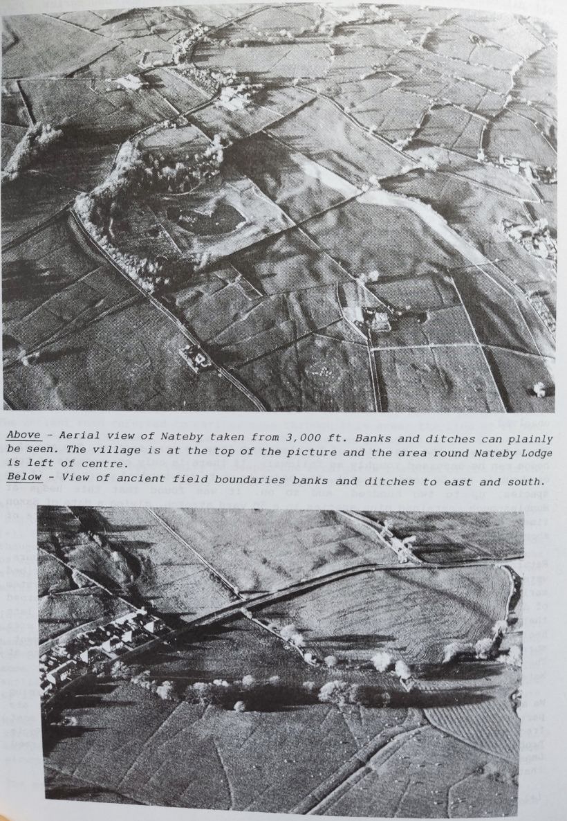
A short distance from here, on what could be described as a small plateau of land there is what appears to be a very early settlement, along with its associated small fields. It occurs within an oval shaped, banked enclosure of about three acres. In the field to the north of here, 150 yards away, is another site probably of the same period. This is on the end of a gravel ridge, halfway down the slope of which there is what appears to be a defensive bank of semicircular shape about 70 yards long. A number of years ago pieces of flint were found here. Much of this high ground is under permanent pasture and has never been ploughed, certainly not within living memory. There are also other enclosures nearby which may be of any age from the Bronze to the Middle Ages. Some of these sites have been discovered with the aid of aerial photographs.
In the field opposite Hoole Lane junction, an aerial photograph revealed the outlines of a rectangular shaped area, some distance into the field. No trace of anything could be seen at ground level. Using a nearby gatepost and a gap in the hedgerow further along the road it was possible to measure the area in the photograph fairly accurately. Measuring 90 yards long by 40 yards wide, what this area could have been remains a mystery.
In the field on the west side of Hoole Lane, immediately behind the hedgerow, is a very large bank. This bank is slightly curved to the left and eventually is crossed by Hoole Lane some 200 yards from the junction with Rawcliffe Road. The bank then enters a wood before eventually emerging into a field still curving to the left. Here, there are what appears to be two entrances, about 30 yards apart, which cut through the bank. It then continues into another field before levelling out into a hillside which is near the small lake mentioned earlier. This is a natural bowl shaped area of about 12 acres. The remains of a large bank on the far side gives the impression that at one time an earth embankment surrounded the whole area.
Nearby, more small fields, some only half an acre in size, can be plainly seen. The ancient road referred to earlier goes through this area; the line of it near to the edge of the lake. The field round the lake was ploughed up for re-seeding during the summer of 1995 and draining operations took place at the same time. The owner had taken the opportunity to deepen and straighten the edge of the lake. At this stage the road was clearly visible across the field.
At one point the excavator dredged up some sections of ancient timber, not unlike 'bog oak', one large piece was similar to those found at the site of Kate's Pad. (*). Some of the pieces showed signs of being worked with a tool. It seemed as though the timbers had been put down to provide a base for the road. Three pieces of wood were rescued from the site and taken away by archaeologists for further study; these were the pointed ends of posts or stakes and showed signs of axe marks.
In fields off Humblescough Lane is another site of interest, probably the oldest. Near here a very good example of a flint knife was found and, not far away, a stone hammer head. Both were of a late Bronze Age date. There are what might be called the outlines of 'hut circles' on some fields. They are shallow depressions of some 18 feet across, but without excavation we cannot be sure. As mentioned earlier, the high ground here is under permanent pasture and for evidence to turn up is rare.
Here, at Humblescough, the Society members discovered a rectangular area of raised earth two feet high, forty yards long and eighteen yards wide which was surrounded by a shallow ditch. It was interesting to note that 'ridge and furrow' ploughing had gone through the site at some time.
The present pattern of squarish, eight to twelve acre fields, as we see them today, were laid down as enclosures in the 18th and 19th centuries. Some of the old ditches were planted with hawthorn to form the new boundaries, but underneath, the earlier, ancient field systems and sunken ways can still be seen. Much work remains to be done in mapping and studying these remains.
Near the site of Old Humblescough House which was demolished in the 1890's, there appears the dry remains of what is thought to be a medieval fishpond. We are told that these were used for keeping a variety of fish, including eels and crayfish. The ponds were made by excavating a shallow rectangular basin. This was split by three banks, two parallel, and the other across it, dividing it into several smaller ponds. The bank needed to be high enough to maintain a pond of moderate depth. It is said there was a spring near to this site and that the women of the village gathered here to wash clothes in a large stone trough by the side of the road. It may have been the same spring that was used to fill the fishpond.
It is almost certain that all the earthworks contained in the doughnut shaped area are of one system. The Nateby and Kirkland Parish boundary which cuts through the system in the Humblescough fields leaves only about a quarter of the earthworks on the Kirkland side. Most parish boundaries were in place by Domesday in 1096 suggesting that all the earthworks must have existed before this time.
The boundary line then continues on to Humbles cough Lane and follows it for its entire length before returning to the fields. Halfway along this lane the boundary suddenly deviates into a field on the Nateby side. It continues as a semicircle, enclosing an area of about three acres before returning to the lane and following its original line. Experts tell us that unexpected or unexplained kinks, bulges or deviations in Parish boundaries should be carefully investigated. As stated earlier, most Parish boundaries were fixed by Domesday and a kink implies that a building or other landmark was in the way and had to be included on a particular side of the line. This mystery at Nateby remains unsolved
The hedgerow on the east side of Humbles cough Lane is very ancient. The age of a hedge can be assessed roughly as follows:- If there is only one species of tree or shrub in any 50 yards stretch, the hedge is up to one hundred years old, if two species, up to two hundred, and so on. It was found that this hedge at Humblescough contained nine species in a 50 yard stretch, giving a date of Saxon times. The hedge on the west side contained only two species, giving a date of about 1800.
Returning to the site at Hoole Lane and of special interest to Society members, were the earthworks near here, consisting of the large curving bank (described earlier) with a very deep ditch on the inside - thus making it useless as a system of defence. For some time this had puzzled members greatly. We recently learned that henges were constructed in this way, making their appearance in the late Neolithic period, around 2,500 B.C. They consisted of an open circular area surrounded by a bank and internal ditch. In some instances the ditch is absent. They vary in diameter from about 50 yards to in excess of 400 yards. The one at Nateby measures 325 yards.
We also learned that henges occur on low lying land close to water, often forming part of a cluster of other related sites and earthworks, the interiors are frequently empty. It is thought their use was for some special purpose, most probably for religious or ceremonial occasions. Following a visit to the Hoole Lane site by archaeologists from London University, it has now been confirmed that this is indeed the site of a henge.
(*) Over-Wyre Historical Journal Vol.1. p 8.