HUMBLESCOUGH LANE
By Neil Thompson
This ancient road leads to Humblescough and Poplar Grove Farms. The name Humblescough is believed to be Norse in origin; the 'scough' meaning a woodland and Huma possibly the name of the owner. The present Humblescough Farm replaced an earlier one known as Old Humblescough, or Humlescow. Although nothing now remains of the buildings above ground, there is much evidence of foundations below the ground. The yard seems to cover about 0.25 of a hectare. This earlier site is about 300 metres from the junction of Humblescough Lane and Skittam Lane, behind the first gateway on the left.
Close by the gate in the past was a freshwater spring and, indeed, even at the present time, the ditch never completely dries up here. Although little is known about the early history of Old Humblescough, it is likely that a farm stood here in Tudor times and probably before that. Indeed, to the south of the site can be seen what appears to be the remains of four ponds, each with a ditch leading to the other. Was the spring the water feeder for these possible fish ponds? In the field to north and east is evidence of medieval field systems and plough scillions with later systems overlying earlier ones in many places. Running east from the site for some distance can be seen the line of a track about 3 metres wide, of a cobble and gravel construction. It is possible that this is connected to the cobble road found near Gibson's Farm in the 1980's when a gas main was laid through it. This track was running east to west in line with the present Longmoor Lane, and evidence would seem to point to this being a predecessor of Longmoor Lane possibly leading to old Green Lane, Nateby (not to be confused with Green Lane East and West at Cabus).
Some distance south of here is Jenny's pit- a small natural sand quarry. In all probability sand was extracted here for use by the inhabitants of the village. Immediately south of the pit is an area of terraced plots with a ditched entrance system. In 1996 members of the Society dug a trial trench on top of the terrace. Quite near the surface another track was found made up of gravel and random cobble, and being about 2 metres wide. Seven metres of the track were uncovered, but no artefacts were found. This track was traced to the very edge of Jenny's Pit. The steep vertical sides of the pit would seem to indicate that it was not part of the entrance to the pit, but that it existed long before the pit was dug. Also on the top terrace are several circular depressions which turned out to have been filled with eighteenth century debris.1.e., pot shards, hand cast brick, timber, etc. The members did not investigate below 300mm, although the ground below was infill. Are these depressions of an earlier age which were filled with the debris from the demolition of the old farm ? The date of the pottery may answer this question.
Humblescough Farm House is a large Georgian building dated about 1750. The barn is possibly older and there is some evidence of an earlier building in the house walls.
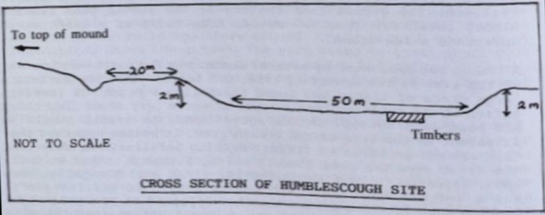
During the Spring and summer of 1996, excavations at Humblescough Farm revealed what may be a pile settlement. Some 200 metres east of the farm buildings is a large depression with a considerable earth bank surrounding it. This has four entrances and appears to be man-made. Approximately 37 metres, widening to about 60 metres, from this is another bank cut into which is a single entrance. The ground from the top of the second bank remains almost level for about 20 metres then there is a ditch which surrounds a low mound.
A trench was excavated by several members on the north-west corner of the site in the summer of 1996. 0.5 metres below the surface a large piece of timber was found resembling a plank. On investigation it was realised that a layer of white carr about 50mm thick had been laid on top. It was agreed that the trench should be extended. As the size of the trench grew, it became apparent that this was not an isolated timber. Running parallel, but away from the first were two more timbers which, although rotted at their ends, appeared to have supported the first one. Alongside these was a large shaped trunk with small axe marks still visible. Running down into the ground was what appeared to be a post about 150mm in diameter. This post was driven tight against the side of the large trunk, and again, axe marks were present on the post. At one end of the large trunk was what seemed to be a joint where another large timber ran away from it and on top of the join a flat 'plank' had been placed to level the area over the join. Again the white carr was present. These timbers seemed to have been laid out in a large rectangular shaped foundation and there were signs of brushwood and clay filling between the timbers. Members concluded that in all likelihood this foundation probably covers the whole area between the two banks (approximately 5 hectares). The bulk of the timbers exposed appear to be alder and oak with the alder being the more predominant species.
The trench was widened on the west side where three riven trunks were found laid side by side, almost as a floor.
The excavation was then filled in (covering the timbers with plastic sheeting) and the site restored under the supervision of the County Archaeologist.
During a smaller excavation carried out in March of that year, about six metres from the above, we located what was possibly post holes varying in diameter from approximately 10mm to 150mm maximum. There seemed to be 6 smaller posts to every large one and the line of the posts appeared to curve and would, if they carried on, form a circle of about 12 to 14 metres in diameter. The timber had completely disappeared leaving a darker soil where the posts had been, but traces of bark were found in several holes. The small posts were placed about 150mm in the ground while the larger were deeper at around 300mm. The soil surrounding the posts contained a deposit of what we now believe to be daub.
Was this find part of a wattle and daub wall from a habitation or a hurdle fence enclosing animal pens ? Further investigation may help to solve this mystery. There were no finds on either site, so again, no date could be established. It was felt, however, by several visitors to the location, that it was more likely to be prehistoric rather than of a later period.
To the south of this area, the meadows are on what, until before World War 2, was the remnants of Ainspool Lake. The lake covered over 80 acres and the Humblescough site is in a small arm on the north edge of this. During later excavations, a sharpened piece of reindeer antler was found along with five flint shards. Mr. J. Meadows of Gibson's Farm, on which part of the site is located, has in his garden, four large boulders. These were taken from close proximity to the site. Also, from the top of the mound, he removed several large blocks of stone which he used to fill in a new silo building at the farm.