
Diary Of A Survey Of An Ancient Highway In Nateby and Over Wyre, Lancashire.
By N. Thompson, W.H. Lawrenson, J. Salisbury, R. Parkinson & D. Thompson. (The Team).
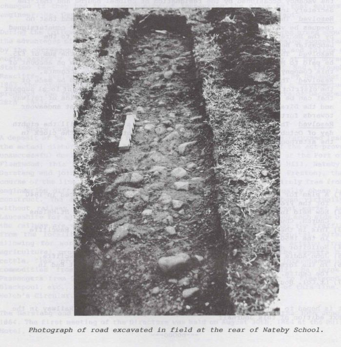
During investigations on various sites in the village of Nateby, the team became aware of a feature resembling the raised agger of a roadway with a ditch on each side, approximately 50m long and 6m wide, running north to south before making a sharp turn to the south west. Mr.W.Myerscough, the landowner, was contacted and he agreed that an investigation trench could be excavated across the feature. On the evening of July 8th, a trench was dug across the site and about 300mm below ground level a paved road was found. The centre of the road was approximately 125mm below the surface and the edges 450mm, thus giving the road a prominent crown. The surface itself was of small cobbles, many of which had been split, and the stones had been set in a light grey silt (white carr). There were three layers of stones before the bottom which had been laid on the red marl bed. The road appeared to have been shaped on this before the stones were laid.
We then turned out attention to the south west end of the road. For about 75m the road surface had been disturbed by a pipeline excavation. However, where Cartmell Lane crosses the line of the road, a bank can be seen matching the crown of the known road. The surface could be traced in the hedge bottom. On the south side of Cartmell Lane in Catons Farm garden, the road had been levelled for some 50m and again from Catons Farm, the path of the road has been levelled for approximately 100m before it appears once more in the field opposite Lodge Cottage (Grid ref. SD463 448). From here the crowned road is evident running south towards the field gate. From the gate the road swings south west under Rawcliffe road and under the garden at Lodge Cottage. (Grid ref. SD463 443).
Report of Excavation in Garden of Lodge Cottage Nateby, 1995.
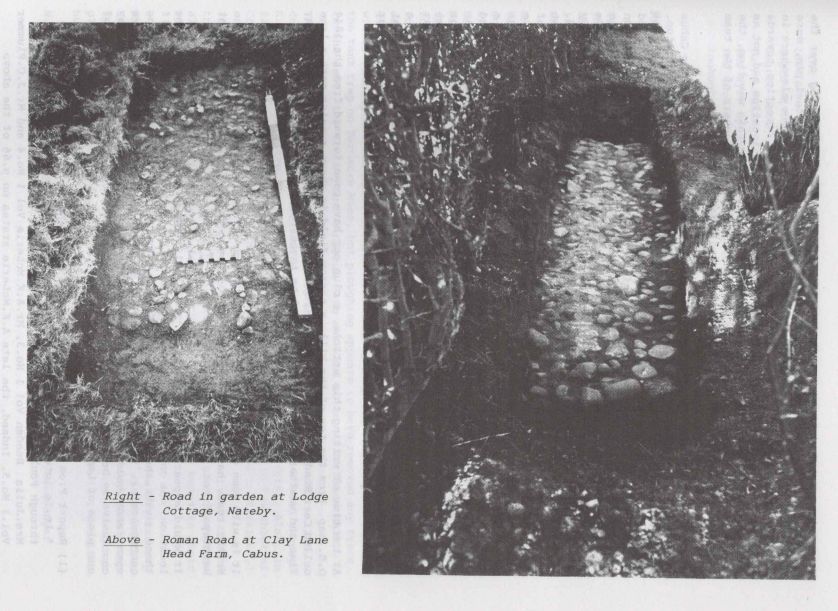
In July 1995 after the agger was found at the rear of the school, J.Salisbury remembered his father telling him about a cobbled path below the garden of Lodge Cottage. It was decided to try and locate the path using steel rods. It was soon found beneath the garden at a depth of about 300mm. J.Salisbury took out a trial trench during the following week and a road some 6m wide was exposed, laid in the same fashion as the one at the rear of the school. i.e., cobble with grey silt fill. The road at this point was found to be some 300mm thick, and again shaped before construction in the red marl. There was some evidence of a layer of gravel having been laid on top of the cobble (small stone and a lighter soil were visible). There was no doubt that this was the same road as at the rear of the school. Later, during October 1995, J. Salisbury dug the excavation out to 7m x 1.5m. Two kerb edges of a larger cobble could now be seen. Although at the present time no evidence has come to light which could date the road, it is obvious this is a major highway, constructed by a very wealthy or powerful body.
It was then decided to try and trace the road through Lodge Hill. This was done by using steel triers. It was noticeable that the perimeter fence near to the garden had a distinct curve at its top. Using the triers, we traced the road in a southerly direction to the top of the hill (SD462 446) and again the fence showed a curve. From here, locating the road became a little more difficult as a pit had been dug through the road in the past. Looking for a continuation at the opposite side of the pit, it was noticed that three trees in the wood were of a stunted growth to the others and on testing the ground the road was found again. From here we went to the Lodge drive. Mr.J.Archer, a local contractor, was ploughing the field for the owner. The line of the road was very obvious in the furrows and led down into a large ornamental lake which had been extended a few years ago. Formerly this may have been an area of swampy ground in the centre of a large depression. In the bottom of the lake many pieces of timber were discovered running along the line of the road. During the construction of the lake, Mr. Smith the owner, and his contractor, Mr.Archer, told the team that they had also encountered worked oak timbers. At the opposite side of the lake a steep ramp was visible and the road could be traced to the top, leading to (SD463 444) the summit of a high ridge. From here the road was traced for 50m in a southerly line.
Report of Investigation of September 1st, 3rd and 10th, 1995.
After research into several maps N. Thompson and J. Salisbury decided to see if it was possible to find the road at other locations behind the school. On early maps starting from the northern end of the agger, a track is shown running across the low lying land to Kilcrash Lane. On investigation this was found to have been no more than an unmetalled path. A series of aerial photographs were then obtained (many thanks to Gerald Carter and his aviators) from which we were able to trace the road to the east, towards a large earthwork. As its course reaches the top of the ridge, almost at the entrance to the earthwork, it turns northwards again (SD465 452). The road now appears to run diagonally across the site till it reaches Hoole Farm (SD465 453), the surface once again being of a cobble construction at this point. From Hoole Farm the line became a little unclear, but it is possible that it followed the course of the present Kilcrash Lane. It was possible to trace it along the footpath from Kilcrash to Nateby Hall for most of its course. While the footpath is not directly on the road it is in very close proximity, taking a straighter line. The road is clearly visible in the bottom of the old railway embankment (SD468 457). In the large field to the south of Nateby Hall, the line is marked by a large litter of stone going across the field. This has probably been caused by ploughing in the past, indeed, Mr.G.Jackson, whose father had ploughed much of this area, recalls that as a young man he was told by his father that he had ploughed through a wide cobbled road in this location. At SD470 460 the line of the road changes from north to north east towards the farm buildings and canal (SD474 463) then follows the southern edge of the canal along the side of a small stream for approximately 400m before it turns at SD475 462. The canal has cut through the road here and we were unable to find some 400m on the other side, but it reappeared again at Nateby Hall Lane (SD479 463) and is easily traceable to the junction with Nateby Crossing Lane (SD483 459). It is believed that the road followed Croston Barn Road although it was not possible to locate it as the road had been resurfaced and widened for a marina development. The workmen employed on this job reported finding a cobbled road below the surface while the work was being carried out. From here it is only a short distance from the road we were investigating to the course of the known Roman road from Walton-le-Dale to Lancaster the link being from Croston Barn Road onto Green Lane West.
Report of 10th, 26th and 27th September and 6th October, 1995.
On Sunday the 10th September it was decided to try and trace the course of the road to the south of Nateby. Permission was obtained from the Mr.J.Willacy for a trial trench to be dug at SD461 443. At approximately 300mm the base of the road was found, this being of the same light grey estuary silt as the previous trial trenches. However, here the cobble appears to have been removed from the site, leaving the base only. Some 200m from this trench the road can be seen in the topsoil of Mr. Willacy's kitchen garden. This shows as silt with a scatter of cobble stone. Efforts were made to trace the road south of here but nothing could be found that evening.
On the evening of September 26th, N. Thompson and J. Salisbury tried to trace the road along a lane to the rear of Shentys Farm (Spencer Veany Lane). There was no evidence of it here and it was decided to look at a westerly course for the road. An investigation in the hedgerows at Manor Farm (SD457 439) revealed traces of a crowned road going in the direction of Grand Agnes Wood (SD446 434). Due to the failing light, work stopped that night. The following evening was spent checking the line of the road from its last known siting in Mr. Willacy's garden to the new location at Manor Farm. Mr.J.Meadows, the owner of Grand Agnes Wood was contacted and permission given for access to the site.
On Friday October 6th N. Thompson and J. Salisbury found the road beneath Hoole Lane at SD459 441. This was done by digging a trench in the road verge which revealed the cobbled road about 300mm beneath the surface. W.H.Lawrenson and R. Parkinson joined the team at 11.00 am and a decision was made to investigate the area around Grand Agnes Wood. Starting at the last known location on Manor Farm at SD452 436, here it was clearly visible as a darker area in the grass pasture going in the direction of Grand Agnes Wood. This dark area joins a track some 300m from the wood and a cutting was taken through this revealing a paved road at a depth of about 450mm. (The land at this point is some 10m above sea level and the road is on top of a ridge). The type of material used in the construction had now changed from cobble to clay and gravel, laid on a heath-like layer of peat below, but still visible was the pronounced crown.
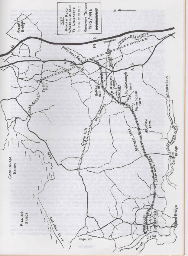 There was some evidence that a ridge had been thrown up and the road laid on top of it. It was more difficult to locate the road to the west of the wood and therefore we moved to the wood opposite on Curlew Farm. (In this area, several pieces of Roman pottery and glass have been found and it is thought that a Romano British settlement may have existed here). On the south side of the wood a bank was discovered and upon investigation, this turned out to be a gravel roadway following the line to Grand Agnes Wood (SD445 434) and the road was found again in several places. The team stopped for the day. In all, some four miles have now been located.
Report of October 21st, 1995.
On the morning of Saturday 21st October, J. Salisbury, H. Lawrenson, N. Thompson and D.Thompson met at Lodge Cottage, Nateby. The morning was spent following the track of a medieval lane at Humblescough Wood. (See Monks Track Document). During the afternoon time was spent visiting several locations on the line of the Nateby road. Test holes were made at Nateby Hall Lane approximately 200m from Nateby Crossing Lane. Here, some 300mm below ground a cobble road was found under a fill of 25mm of road stone; the road stone being placed during the resurfacing of the lane in recent times. On the north side it was possible to find traces of the cobble road, but this had been disturbed at the side by a trench. (Water Pipe line).
A second trench was dug on Hoole Lane to establish the crossing point. The cutting described in the report of the 1st., 3rd and 10th September was reopened and extended the road could clearly be seen at this point. We then followed the track from here to the boundary of Manor and Rough Holme Farms. The line is easily traced by several lane crossings and by a raised agger visible near Manor Farm. It was agreed that we try to follow this line from its last known point near to Curlew Farm at SD443 435 towards Rawcliffe at a future date.
Report of October 30th, 1995.
The team met at the home of Mr. J. Salisbury on the morning of October 30th with the intention of tracing the road further. The first location tried was at SD426 432. Here, the footpath from Eskham crosses the path of an old lane from Gt.Eccleston Road near to Tile Sheds House (approx. 100m north of Valiants Farm). This lies in direct line with the path of the road traced to SD433 435 on October 21st. The old lane was found to be cobbled at a depth of about 300mm below the lane's surface and over a width of about 6m. Ditches are visible on either side of the lane. A close examination showed that in recent times the lane had been used as a farm track to access fields, but as at Nateby Hall Lane, only half the width of the road has been used for this purpose. At the western end of the lane, it appears to have crossed Gt.Eccleston Road and the present Crookgate Lane is now laid on the path of the road. Although the two do not exactly match, if one stands down Crookgate Lane about 50m from the junction, it is possible to see the old course of the road (SD421 429 approx.) An extensive search was carried out to try and find the route from Crookgate Lane and it was not until late in the afternoon that we had a possible lead. Due to the time we could not carry out any more work here - although we had a new lead but the team believe that the road follows the course of Crookgate Lane.
Report of Excavation of Roman Road at Clay Lane Head Farm, Cabus.
Friday 15th December, 1995.
The team decided to carry out an excavation on the known Lancaster to Walton-le- Dale Roman road to see if there was any similarity between it and the Nateby Road. The owner, Mr. Clifford Higginson, gave permission for a trial excavation.
A line was taken from the known route of the Roman road from Fowler Hill and it became apparent that the road ran under the centre of the farm house. Mr.Higginson recalled that in the 1950's the road had been uncovered during the laying of a main drain in the garden of the farm and this gave a rough indication. to where it may be sited. It was to prove difficult as several drains and a large ditch have crossed the area. Three possible locations were found and the ground was tried using steel pins. Just before lunch, in the field to the south of the farm garden, against the fence some 35m from the line of the A6 road, a possible site was chosen. After lunch a trial trench was dug by J.Salisbury and W.H.Lawrenson and approximately 450mm below ground level, a scatter of small cobble and gravel was found. N. Thompson used the steel pins about 2m into the field alongside the southern fence next to the bungalow drive. About 150mm down the road was located. The digging of a trial trench across the site revealed a layer of larger cobble set in sand, and there was some evidence of a gravel layer having been laid on the top surface. The construction of this road is very similar at this point to the Nateby road at the rear of the school. It was possible to trace only half of the road from the edge to the top of the crown on the west side as a large drain had been laid through the east side, destroying what remained. If we assume that we have half the road's width and this measured 3.5m, then we could. expect the road to have measured a total of about 7m across at this point (22ft). Several more soundings were taken between the two excavations a distance of about 7m but this again proved difficult due to the land being disturbed.. Although no excavation was done in the farm garden, a hard surface was found with. the pins some 300mm down. Again, this was approximately 7m wide and in line with the centre of the house and the sites in the field. Looking once more at the first site, is it possible that the cobble surface has been removed to cobble the farm yard at some time in the past? Many stones in the yard seem to match the type found at the second site. From these locations, if a line was taken south, it would appear that the road would join Green Lane East very close to the Garstang Show Ground car park entrance. This is some 300m from the possible junction with the Nateby road.
By N. Thompson, W.H. Lawrenson and J. Salisbury.
Report of January 12th, 1996 of Dig at Clay Lane Head Farm, Cabus.
The team met at Clay Lane Head Farm at 10.30 am. It had been decided that we enlarge the existing trench to enable a good cross section to be photographed. J.Salisbury and W.H.Lawrenson began enlarging the trench. While this work was going on, N. Thompson and R. Parkinson, using range poles, laid out the route of the road across the field. We were still of the opinion that it was between 5.5m to 6.5m wide. By checking its position at the two 'try' holes dug on the 15th of December, 1995 and lining these up to the trench being worked on, the route of the road was quickly established. N. Thompson and R. Parkinson then relocated the road in the farm garden and it became apparent that it had been well over 6.5m wide and was probably more in the region of 7.5m. Mr. Higginson, came across to look at the work, then gave permission for a trench to be dug in the garden, by which time work on the completion of the first trench had exposed some 3.5m x 2m of rough cobble and gravel, with apparent damage caused by ploughing. A single sherd of light brown unglazed pot was found, about 8mm thick, and also several pieces of coal and red clay similar to finds on the Nateby road. Again, the team felt that the construction was almost the same as that at the rear of Nateby School. The road surface here was of river gravel and stone. The present day River Wyre runs some 400m from the site and probably did in Roman times. Whilst there are many river washed cobbles in the surface of the road, most of the stone is of 40mm down to sand. It was agreed to leave the site till after lunch to allow the surface to dry out before it was photographed. The team then moved into the garden and a point in the centre of the lawn was chosen. The reason for this is that the garden is split into two lawns and the road runs under both.. A footpath runs through the centre giving access for a trench without disturbing the flower beds. We decided that only a spade wide trench would be dug to avoid damage to the garden area. The location of the road was established using steel triers, the boundary of the trench marked and the turves removed and stored. Approximately 350mm below ground level the road surface was found again, constructed of stone and gravel as before. The east and west edges of the road were found and measured giving a width of 7.5m. The A6 road is about 0.5m less in width at this point, and the Roman road lies some 35m east of it. The road surface here was complete over the full width unlike the other site where the east side was missing.
After lunch the first trench and line of the road were photographed and also the second trench and the line of the road to the house. Following this, the first trench was refilled and the ground reinstated. Work moved to the new trench in the garden. It was decided to dig out a section to find the depth of the road. About 150mm down the surface of a clay bed was exposed but no stone was found below this level. It is now thought that this surface was more likely to be the base of the road rather than the top and that at some time in the past the layer of stones had been removed from the site for other use. If one examines the garden walls and flower beds there is much evidence of cobble, etc., in them. Mr.Higginson says that the family have removed many stones from the garden in the past. To add to this, on the west edge of the road, three large cobble stones were found lying on the top. On completion of photographs, etc., the trench was refilled and the ground reinstated.
By N. Thompson, W. H. Lawrenson, J. Salisbury and R. Parkinson.
Some Observations
We have established the line of the road for some 500m and a probable line for about a kilometer from Fowler Hill to Green Lane East. We have also established a width of 7.5m. There is a mystery as to the actual construction of the surface of this road, but most of all, we have found that the Nateby road could be of a similar age. While Cabus seems a long way from Nateby, the team members felt that it was important to locate and record what they found on this site. There are several reasons for this:-
1. The Nateby road is believed to have joined this road at a point about 300m south of the Garstang Show Ground entrance on Green Lane East.
2. There is little evidence of any excavation of the Lancaster/Walton le
Dale Roman road in this area.
3. The need to see if the two roads were alike in construction.
4. To give a little more information on the past to our area.
Whilst the team have no further plans at present to dig any more of the Cabus road, our research may, in future, prompt some like minded group to investigate further.
Report of February 16th, 1996.
The team met at Lodge Cottage at 10.00 am. Permission had at last been obtained from Mr.B.Grayston to walk across Hoole Farm. Due to a change in ownership this had not been possible till now. The road was quickly located at the rear of the farm and was visible as a raised agger running north across the field through the farm garden and the eastern entrance to the farm. The previous owner, Mrs.M.Exton, had told J. Salisbury that whilst planting trees a cobble road had been encountered but had believed this had been used to take cattle to a nearby pit to drink in the past. We moved into the field opposite the farm across Kilcrash Lane and a scatter of cobble on the suface of the field opposite the farm entrance could be seen; there was evidence of more cobble below the surface at this point.
Walking down the field it became obvious that ploughing over the years had left a cobble scatter some 10m to 15m wide. Using the steel pin, more cobble was found below the surface. There was no evidence of stone elsewhere in the field in any quantity. The scatter runs in a northerly direction towards Nateby Hall and it now seems likely that the road is in this location and not as previously thought along the line of Kilcrash lane. Following this new line, the road would join the known section to the rear of the Bowers. Members of the team were better satisfied with this route than the previous one.
Having arrived at a satisfactory conclusion to our route for the road from Cabus to Rawcliffe, it was agreed that the rest of the day should be spent at Hambleton. From Crookgate Farm (SD401 423) a footpath crosses to Back Lane (Turkey Street) (SD393 425). N. Thompson had been talking to a local landowner and had established that a ridge of dry land exists on or near to this footpath. On investigation a hard surface was discovered some 300mm below ground level. On the west side of Back Lane the footpath is along a green lane for approximately 100m and this was found to be about 6m wide with a ditch on either side and with a very pronounced crown. At a depth of some 300mm there was evidence of a cobbled road. At its western end, the lane runs out into a field in which there was a great. quantity of water worn cobbles laid on the soil. There is much evidence of ploughing in this field and it was not possible to locate anything positive here until we came to the western end. Here, and in the next field, can be seen an agger (SD385 425) before the road crosses Cutts Lane (SD385 426). Near Noars Farm a distinct bump in Cutts Lane is very visible. After crossing Cutts Lane, the road runs north for approximately 100m before turning west along a distinct agger towards Bickerstaff Farm (SD383 427). Much ploughing has been done in previous. year in the field near the farm. The team proceeded to School Lane and at Crooklands Farm a sunken track (SD377 426) leads to the top of the hill (SD377 428). Here, in a direct line with Bickerstaff Farm and Wardleys (SD365 429), a large scatter of cobble some 30m wide could be seen. There seems little doubt that the road is making for Wardleys, but more research will be carried out in the near future to try and confirm this.
At the time of writing this article, a clue may have come forward from the 1844 O.S. map. From the top of the hill, a narrow field is shown running onto a lane called Carr Road and this road in turn leads to a path going directly to Wardleys. Time and weather permitting, we intend to investigate this possible route.
Conclusion
It is with some excitement that this conclusion is written to our research of the Nateby road, having traced it's path to within 200m of the Wardleys Hotel at Wardleys Creek.
It would appear that we have two 'roads' (1) apparently heading for the same location: one on the west bank and the other on the east bank of the River Wyre. If these roads should prove to be of Roman origin, is it possible that the controversial 'Portus Setantiorium' was situated in this area? The team have spent many hours following this road, and whilst our findings are in no way conclusive we hope that we are able to offer some new evidence to the history of our piece of Lancashire.
(1) Report From the Lancashire Historical Bulletin Vol.1 No's 3,4 & 5. "It is interesting to note that in the 1970's the tracing of a road through Poulton towards the Wyre was reported in the above journal by Mrs. Julia Beeden Vol 1 No.3, Mr.A.K.McLerie Vol 1 No.4 and Mr.J.C.Plummer Vol.1 No.5. Indeed, the late A.K. McLerie states on p.66 of the above journal:-
'The northern extension of Links Gate calls for some treatment. On the 1844 6" O/S.map Ardelles House does not occur, but its site is within the angle of the track, which here ceases to travel north and makes a 45 degree bend to the north east. Continued in its new direction it appears to be making for that conspicuously elevated point on the western bank of the Wyre opposite "Wardleys". Needless to say, the elevated situation of the here suggested destination of the track would afford an excellent lookout for river traffic, both to the north and south of "Bergerode"."
The Monks Track.
Report of a Survey at Humblescough Wood, Nateby. October, 1995. By The Nateby Team
Some weeks before the survey was carried out it had been reported to J. Salisbury that a track could be seen in Humblescough Wood. Permission was sought from the landowner for access to the wood and this was granted. The team set off to investigate the site on the 21st October. The wood is about half a kilometer from the farm and the track is at the eastern end across the old tank trap..
On arrival at the site the raised trackway was clearly visible. A cutting was taken across and a rough cobble path was found some 150mm below ground. The cobbles did not appear to have been set into the surface, more likely they had simply been tipped and levelled. There was no evidence of any type of binding holding the stones together as is the case on the other road through the village. Ditches could be seen on either side of the track and the cobbles were little more than a stone deep. There was some evidence of repair work. Amongst the stone we found several pottery sherds and remains of rough tile or brick; possibly the rubbish left over from a firing. Several small pieces of coal were also found. A measurement of the track was taken from its location at SD474 436 for 90m to SD472 436 where the tank trap has cut through it. It measured between 2.5m and 3m in width, running east to west. Efforts were made to find the track to the west of the tank trap on Tarnacre Moss, but ploughing appears to have removed any trace. To the east, the track joins Ainspool Farm road and so on to Kirkland Hall.
The monks of Cockersand Abbey held lands on Tarnacre Moss and in 1282 1285, a covenant by John of Kirkland granted to the monks of Cockersand a road through Kirkland Wood to drive their beasts and carry their turves (turbis). Also, in 1274 (approx.) John, son of John the tailor of Kirkland granted to the Abbot of Cockersand..that they wholly should take forever the dead wood in Kirkland. '
It is likely that Humblescough Wood is a remnant of the Kirkland Wood mentioned in the covenant, and the track leads to Tarnacre Moss, so it would seem that it is all that remains in its original form of the track built by the monks to their land at Tarnacre.
* A description of the tank trap may be required by the reader to clarify exactly what it is. The tank trap was built during World War Two as part of the western defence system and in the area around Nateby can now be seen as a large ditch; the theory being that tanks would be unable to cross this obstruction. In other places, large square blocks of concrete can still be seen laid out in lines like hugh teeth.
N.B. All grid references in the above articles are from the O.S.Landranger 102, Preston, Blackpool and surrounding area.